
Title: Simmons Sunset
Digital Art
NWJ
Art
Art by Norman Johnson
Explore St. Augustine, Florida
Fine Art for Home and Office
Landscapes
Pictures of all types of landscapes from Argentina, Costa Rica and the United States.
Browse the images below and travel from mountains, volcanoes and waterfalls to deserts and canyons.
Take rivers and streams to lakes and ponds.
Visit bayous, and fresh and salt water marshes. Then go inland to springs, fields and pastures.

Across The Valley
The painted Desert was named in 1540 by Francesco Vazquez de Coronado. These badlands in the Four Corners area are approximately 120 miles long and 60 miles wide, extending from the east end of the Grand Canyon National Park southeast to the Petrified Forest National Park and north to the Navajo Nation. It is made up of easily erodable rock which allows the different layers of deposits to be exposed,
Click image to see full picture

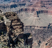
Maricopa Point Grand Canyon
The Colorado Plateau, through which the Grand Canyon cuts. was once a seabed.The plateau was raised through plate tectonic action so that the rims of the grand canyon are now between 7,000 and 8,000 feet above sea level. Through erosion from the Colorado River and other factors, the canyon has been cut as deep as one mile in places. The canyon can be viewed from both the north and south rims. This is a view from Maricopa Point on the south rim of the canyon.
Click image to see full picture

Rock Face
The Chisos Mountains, at almost 8,000 feet, are one of the focal points of the Big Bend National Park in Texas.
The Big Bend National Park, with over 800,000 acres encompasses river, desert, mountain and canyons. The elevations range from less than 1,800 feet along the Rio Grande River to almost 8,000 feet in the Chisos Mountains.From forested mountains, to vast deserts and from springs to river country, there is something for everyone. It is one of the remaining last wild corners of the United States.
Click image to see full picture
Powell Point
The Colorado Plateau, through which the Grand Canyon cuts. was once a seabed.The plateau was raised through plate tectonic action so that the rims of the grand canyon are now between 7,000 and 8,000 feet above sea level. Through erosion from the Colorado River and other factors, the canyon has been cut as deep as one mile in places. The canyon can be viewed from both the north and south rims. This is a view from Powell Point on the south rim of the canyon.
Click image to see full picture

More Jumbles
The painted Desert was named in 1540 by Francesco Vazquez de Coronado. These badlands in the Four Corners area are approximately 120 miles long and 60 miles wide, extending from the east end of the Grand Canyon National Park southeast to the Petrified Forest National Park and north to the Navajo Nation. It is made up of easily erodable rock which allows the different layers of deposits to be exposed,
Click image to see full picture
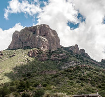
Standing Proud
In spite of the obvious erosion, the Chisos Mountains in the Big Bend National Park of west Texas, still reach almost 8,000 feet of elevation.
The Big Bend National Park, with over 800,000 acres encompasses river, desert, mountain and canyons. The elevations range from less than 1,800 feet along the Rio Grande River to almost 8,000 feet in the Chisos Mountains.From forested mountains, to vast deserts and from springs to river country, there is something for everyone. It is one of the remaining last wild corners of the United States.
Click image to see full picture

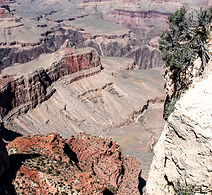
South Rim View
The Colorado Plateau, through which the Grand Canyon cuts. was once a seabed.The plateau was raised through plate tectonic action so that the rims of the grand canyon are now between 7,000 and 8,000 feet above sea level. Through erosion from the Colorado River and other factors, the canyon has been cut as deep as one mile in places. The canyon can be viewed from both the north and south rims. This is a view from a scenic overlook between Powell Point and Hopi Point on the south rim of the canyon.
Click image to see full picture

Pinched Earth
The painted Desert was named in 1540 by Francesco Vazquez de Coronado. These badlands in the Four Corners area are approximately 120 miles long and 60 miles wide, extending from the east end of the Grand Canyon National Park southeast to the Petrified Forest National Park and north to the Navajo Nation. It is made up of easily erodable rock which allows the different layers of deposits to be exposed,
Click image to see full picture

Contrast
The Chisos Mountains in the Big Bend National Park of west Texas come in many sizes and shapes.
The Big Bend National Park, with over 800,000 acres encompasses river, desert, mountain and canyons. The elevations range from less than 1,800 feet along the Rio Grande River to almost 8,000 feet in the Chisos Mountains.From forested mountains, to vast deserts and from springs to river country, there is something for everyone. It is one of the remaining last wild corners of the United States.
Click image to see full picture
Maricopa Vista
The Colorado Plateau, through which the Grand Canyon cuts. was once a seabed.The plateau was raised through plate tectonic action so that the rims of the grand canyon are now between 7,000 and 8,000 feet above sea level. Through erosion from the Colorado River and other factors, the canyon has been cut as deep as one mile in places. The canyon can be viewed from both the north and south rims. This is a view from Maricopa Point on the south rim of the canyon.
Click image to see full picture

One After Another
The painted Desert was named in 1540 by Francesco Vazquez de Coronado. These badlands in the Four Corners area are approximately 120 miles long and 60 miles wide, extending from the east end of the Grand Canyon National Park southeast to the Petrified Forest National Park and north to the Navajo Nation. It is made up of easily erodable rock which allows the different layers of deposits to be exposed,
Click image to see full picture

Test Of Time
A lone standing peak in the desert of the Big Bend National Park of west Texas.
The Big Bend National Park, with over 800,000 acres encompasses river, desert, mountain and canyons. The elevations range from less than 1,800 feet along the Rio Grande River to almost 8,000 feet in the Chisos Mountains.From forested mountains, to vast deserts and from springs to river country, there is something for everyone. It is one of the remaining last wild corners of the United States.
Click image to see full picture