
Title: Simmons Sunset
Digital Art
NWJ
Art
Art by Norman Johnson
Explore St. Augustine, Florida
Fine Art for Home and Office
Landscapes
Pictures of all types of landscapes from Argentina, Costa Rica and the United States.
Browse the images below and travel from mountains, volcanoes and waterfalls to deserts and canyons.
Take rivers and streams to lakes and ponds.
Visit bayous, and fresh and salt water marshes. Then go inland to springs, fields and pastures.

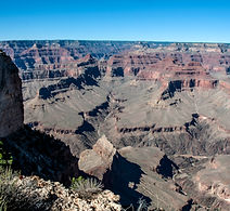
Grand Canyon Hopi Point
The Colorado Plateau, through which the Grand Canyon cuts. was once a seabed.The plateau was raised through plate tectonic action so that the rims of the grand canyon are now between 7,000 and 8,000 feet above sea level. Through erosion from the Colorado River and other factors, the canyon has been cut as deep as one mile in places. The canyon can be viewed from both the north and south rims. This is a view from Hopi Point on the south rim of the canyon.
Click image to see full picture

Striations
The painted Desert was named in 1540 by Francesco Vazquez de Coronado. These badlands in the Four Corners area are approximately 120 miles long and 60 miles wide, extending from the east end of the Grand Canyon National Park southeast to the Petrified Forest National Park and north to the Navajo Nation. It is made up of easily erodable rock which allows the different layers of deposits to be exposed,
Click image to see full picture

Mojave Point
The Colorado Plateau, through which the Grand Canyon cuts. was once a seabed.The plateau was raised through plate tectonic action so that the rims of the grand canyon are now between 7,000 and 8,000 feet above sea level. Through erosion from the Colorado River and other factors, the canyon has been cut as deep as one mile in places. The canyon can be viewed from both the north and south rims.This is a view from Mojave Point on the south rim of the canyon.
Click image to see full picture

Patterned Skirts
The painted Desert was named in 1540 by Francesco Vazquez de Coronado. These badlands in the Four Corners area are approximately 120 miles long and 60 miles wide, extending from the east end of the Grand Canyon National Park southeast to the Petrified Forest National Park and north to the Navajo Nation. It is made up of easily erodable rock which allows the different layers of deposits to be exposed,
Click image to see full picture

Hopi Point Grand Canyon
The Colorado Plateau, through which the Grand Canyon cuts. was once a seabed.The plateau was raised through plate tectonic action so that the rims of the grand canyon are now between 7,000 and 8,000 feet above sea level. Through erosion from the Colorado River and other factors, the canyon has been cut as deep as one mile in places. The canyon can be viewed from both the north and south rims. This is a view from Hopi Point on the south rim of the canyon.
Click image to see full picture

Layers Exposed
he painted Desert was named in 1540 by Francesco Vazquez de Coronado. These badlands in the Four Corners area are approximately 120 miles long and 60 miles wide, extending from the east end of the Grand Canyon National Park southeast to the Petrified Forest National Park and north to the Navajo Nation. It is made up of easily erodable rock which allows the different layers of deposits to be exposed,
Click image to see full picture

Hopi Point View
The Colorado Plateau, through which the Grand Canyon cuts. was once a seabed.The plateau was raised through plate tectonic action so that the rims of the grand canyon are now between 7,000 and 8,000 feet above sea level. Through erosion from the Colorado River and other factors, the canyon has been cut as deep as one mile in places. The canyon can be viewed from both the north and south rims. This is a view from Hopi Point on the south rim of the canyon.
Click image to see full picture

Cake Layers
The painted Desert was named in 1540 by Francesco Vazquez de Coronado. These badlands in the Four Corners area are approximately 120 miles long and 60 miles wide, extending from the east end of the Grand Canyon National Park southeast to the Petrified Forest National Park and north to the Navajo Nation. It is made up of easily erodable rock which allows the different layers of deposits to be exposed,
Click image to see full picture
Monument Creek Vista
The Colorado Plateau, through which the Grand Canyon cuts. was once a seabed.The plateau was raised through plate tectonic action so that the rims of the grand canyon are now between 7,000 and 8,000 feet above sea level. Through erosion from the Colorado River and other factors, the canyon has been cut as deep as one mile in places. The canyon can be viewed from both the north and south rims. This is a view from the Monument Creek Vista on the south rim of the canyon.
Click image to see full picture

Hopi Vista
The Colorado Plateau, through which the Grand Canyon cuts. was once a seabed.The plateau was raised through plate tectonic action so that the rims of the grand canyon are now between 7,000 and 8,000 feet above sea level. Through erosion from the Colorado River and other factors, the canyon has been cut as deep as one mile in places. The canyon can be viewed from both the north and south rims. This is a view from Hopi Point on the south rim of the canyon.
Click image to see full picture

Grand Canyon Mojave Point
The Colorado Plateau, through which the Grand Canyon cuts. was once a seabed.The plateau was raised through plate tectonic action so that the rims of the grand canyon are now between 7,000 and 8,000 feet above sea level. Through erosion from the Colorado River and other factors, the canyon has been cut as deep as one mile in places. The canyon can be viewed from both the north and south rims.This is a view from Mojave Point on the south rim of the canyon.
Click image to see full picture

The Abyss
The Colorado Plateau, through which the Grand Canyon cuts. was once a seabed.The plateau was raised through plate tectonic action so that the rims of the grand canyon are now between 7,000 and 8,000 feet above sea level. Through erosion from the Colorado River and other factors, the canyon has been cut as deep as one mile in places. The canyon can be viewed from both the north and south rims. This is a view from The Abyss on the south rim of the canyon.
Click image to see full picture